REPORT FOR:
MOUNT KEMBLE LAKE
ASSOCIATION INC.
AQUATIC MACROPHYTE
SURVEY
SEPTEMBER 11, 2006

Allied
Biological, Inc.
ph (908) 850-0303 fax (908) 850-4994
I.
Introduction
On September 11, 2006 Allied Biological, Inc. conducted a
detailed aquatic macrophyte survey at
II.
Procedures
Before the survey began, random sample locations were
plotted on a hand-drawn map of the lake focusing on the littoral areas. The
points were aligned in transects in an effort to sample both the shoreline and
open water communities. The total number of sample locations is based on the
total acreage of the lake. As a rule of thumb, one sample location per acre
(minimum 50 sample locations) is surveyed. If the lake is over 100 acres in
size, the number of sample locations is reduced to about 100. Since every lake
is different, the survey can focus on problematic locations according to the
client’s instructions. It should also be noted that deeper water areas (total
depth greater than 15 feet) are generally not surveyed due to the lack of
aquatic macrophyte growth caused by poor light
penetration. The sample locations are depicted on a map at the back of this
report.
Using the hand-drawn map as a guide, the survey boat is
piloted to the first sample location. On arrival, the GPS coordinates of the
sample location are recorded using a TeeJet Smartpad II (ver. 4.02, or
equivalent), and a Midtech High Accuracy Differential
Receiver (RX 400p, or equivalent). The water depth is also measured, using a
boat mounted depth finder, or a Fish Ray depth gun (Aquatic Ecosystems, model
FR-100, or equivalent). The water depth is recorded on a field log, and is
depicted on a map. Any other pertinent field notes regarding the sample
location are also recorded on a field log.
Next, a weed anchor attached to a 10 meter-long piece of
rope is tossed from a random side of the boat. It is important to toss the weed
anchor the full 10 meters (a loop at the end of the rope should be attached to
the boat to prevent losing the anchor). The weed anchor is slowly retrieved
along the bottom, and carefully hoisted into the boat. To determine theoverall submersed vegetation amount, the weed mass is
assigned one of five densities, based on semi-quantitative metrics developed by
tines of the anchor), or Dense (entire anchor full of stems, and
one has trouble getting the mass into the boat). See the appendix of this
report for pictures of these representative densities. These densities are
abbreviated in the field notes as 0, T, S, M, and D. Next the submersed weed
mass is sorted by Genus (or species if possible) and one of the five densities
(as described above) is assigned to each Genus. Finally, overall floating macrophyte density within a 10 meter diameter of the survey
boat is assigned a density, as well as an estimated density for each separate
genus (or species). This data is recorded in the field notes. This procedure is
then repeated for the remaining sample points.
A sample of each different macrophyte
is collected and placed in a bottle with a letter or number code (A, B, 1, 2,
etc.). If possible, these samples should include both submersed and floating
leaves (if any), seeds, and flowers (if present), to facilitate identification.
These bottles are placed in a cooler stocked with blue-ice packs or ice, and
returned to Allied Biological’s lab for positive
identification and photographing. Regionally appropriate taxonomic keys are
used to identify the aquatic macrophytes (see section
V for a list of references).
The weed anchor used for aquatic macrophyte
surveys has a specific design. It is constructed with two 13.5-inch wide metal
garden rakes attached back to back with several hose clamps. The wooden handles
are removed and a 10 meter-long nylon rope is attached to the rake heads.
III.
Macrophyte Summary
The following aquatic macrophytes
were observed at
11, 2006. The respective plant densities are summarized on table #1
in the appendix. In
addition, the distribution of each individual macrophyte
is depicted on separate maps
located in the appendix of this report. Below is a short
description of each macrophyte and
a picture.
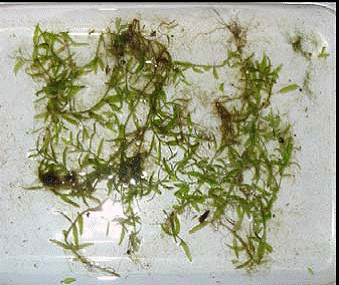
Water Starwort (Callitriche sp.) (see below) are commonly found in this region. This species
typically grows in shallow shoreline portions of lakes and ponds. It can be
found in coves and swampy sections of lakes and ponds. This species rarely
grows to nuisance densities. This aquatic species is grazed on by ducks and
fish and also creates cover for young fish.
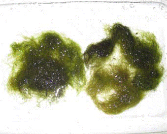
Benthic and Floating Filamentous Algae: Filamentous algae (see below) are a chain or series of similar algae cells
arranged in an end to end manner. Benthic filamentous algae are attached to a
hard substrate, such as logs, rocks, a lake bottom, or even other aquatic plants.
When growing in heavy densities, benthic filamentous algae can appear as brown
or green mats of vegetation that can reach the surface. When large pieces break
off the bottom substrate they become floating filamentous algae patches.
Benthic filamentous algae can comprise an entire range of morphologies, but
flagellated taxa are far less common.
IV.
Discussion
At the back of this report are total of 5 maps. One of these
maps represent the distribution of the lone aquatic macrophyte according to species location. The remaining
four maps depict sample station distribution, water depth distribution, total
aquatic vegetation distribution, and total algae distribution for
A total of 89 sample locations were surveyed at
In addition to surveying the aquatic vegetation, water depth
readings were recorded at all 89 sample locations, using a boat mounted fish
finder. In the case of shallow water and/or extensive vegetation beds that
would interfere with the depth finder, a pole was used to measure water depth.
An average depth of 10.61 feet was calculated from these 89
measurements.
One submersed aquatic macrophyte
and benthic filamentous algae were observed at
Water starwort was collected at only 2 (or 2%) of the sample
sites. One of the sites returned trace densities, and the other returned sparse
densities each site was ~ 1% of the total sites sampled..
This species was also visible at sparse densities along the shoreline from two
of the sample sites.
Benthic filamentous algae was collected at 16 (or 18%) of the locations surveyed. It was collected
at 8 (or 9%) of the sites at trace density. At 8 (or 9%) of the sites surveyed,
it occurred at sparse density. This species was at non-nuisance densities
throughout the lake and was not even visible through the majority of the sites
sampled.
V.
References
Through the Looking Glass: A Field Guide to Aquatic Plants.
1999. Borman, et al.
Effective Aquatic Plant Monitoring: Data and Issues from